We were now in the Ruby Mountain Ranger District heading west towards Austin, and as Lady and I made our way to Overland Pass at the southern end of the Ruby Mountains, we passed weekender camper vans parked up in pretty little camping spots among the trees. ATVs indicated that many of them were evidently out on hunting expeditions. This was probably for elk at this time, but other big game commonly hunted in Nevada are antelope, black bear, bighorn sheep, mountain goat and mule deer. Licences to hunt are issued on a quota basis and hunting seasons for the different species, which can vary from one to several weeks, are generally in the late summer/autumn period.
The name of this pass is slightly confusing in that it was a less elevated version of a more significant, higher and steeper Overland Pass in the Diamond Range which we to cross the following day.
Through this pass the Pony Express Trail briefly merges with the Hastings Cutoff section of the California trail where it loops south round the Ruby mountains. The Cutoff was pioneered and promoted by Lansford Hastings in 1845 as a more direct emigrant route to California, though it did not prove to be so. At the junction ahead the Hastings Cutoff turned to the right, following the Huntingdon valley north to join the Humboldt valley, while we would carry on to the left and over the Diamond Mountains on the horizon...
It was to the right that the doomed Donner party of California-bound emigrants turned in 1846, their delayed journey on this cutoff leaving them snowbound in the Sierra Nevada. Many died of starvation though some survived by resorting to cannibalism of dead bodies.
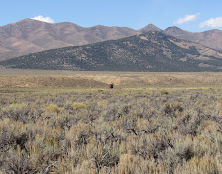
The water tower across the sage brush to the north of the track probably marks the site of Jacob's Well Pony Express way station, with the Diamond Mountains behind....
This station was not mentioned by Burton, but may have been built shortly after. Edna Patterson writes "There was one station in between and that was Jacob's Well which lies in the valley between two ranges of mountains. This valley of sagebrush was dry and desolate, but a change station was needed every ten or twelve miles, so a little cabin was built of stone to serve as a station. It was built by men under General Frederick Jacobs, of Indian War fame, who had been charged with the construction of the road and building. A well was also built to supply water at this station and it was then given the name of Jacob's Well. Today nothing remains but a few old stones from which the old well has long since caved in with rock and dirt."
The summit of the pass was bleak and bitterly cold with flecks of snow whirling in a biting wind. I was thankful to be descending the rough track down Telegraph Canyon on the other side with a sunny view ahead in Diamond Valley, which Burton called "Moonshine Valley"..
You can see Lady's saddlebags which were carrying water containers in case there was no water en route, but in fact at the end of the canyon we came to Diamond Ranch where there was a large trough of clean spring water. A little further on we found the monument to Diamond Springs Pony Express station where I decided to stop for a lunch break..
Here are ranch owner Daniel Venturacci (on the left) and sidekick Ben Reed who came over to chat..
Dan has not long moved onto the ranch with his wife, and runs about five hundred head of cattle on several thousand acres of land.
The exact site of the Pony Express station seems to be rather confused. Most sources seem to put it in a cottonwood grove about a mile north of the ranch. But the plaque on the monument located it 350ft southwest of the monument, and Dan told me the stone building at that spot (shown in the photo below) apparently dates from the mid 1800s and is believed to incorporate the former station.....
As he pointed out, it is not in its original state, having been converted into a garage (not by him he was keen to add), but if you look carefully at the gable end you can see the port holes used for firing at attackers.
In fact Diamond Springs was another station that escaped Indian attack, though Burton rather smugly commented that the Mormon couple who were running it when he passed through and were "not particularly civil", and afterwards "had to fly before the savages - which perhaps they will be pleased to consider a 'judgement' upon them".
A view across the rabbit brush near Sulphur Springs after ten miles trudging across the flat Diamond Valley...
The aptly named rabbitbrush is a yellow flowering shrub commonly found in arid areas in North America, particularly lining the roads. It is eaten by the jackrabbits (or desert hares) which flourish in this area - they lolloped across the track every few minutes.. Dan told me they had shot about five hundred on the ground near the ranch on one occasion, but that they don't taste too good!
Sulphur Springs Pony Express station was sited off to the right at the base of the Sulphur Springs Range. It was probably established as a way station as late as July 1861, and was then used as an Overland stage stop until 1869. The trail ran round the tip of the promontory to the right in the middle distance, and we camped just the other side of it.


No comments:
Post a Comment